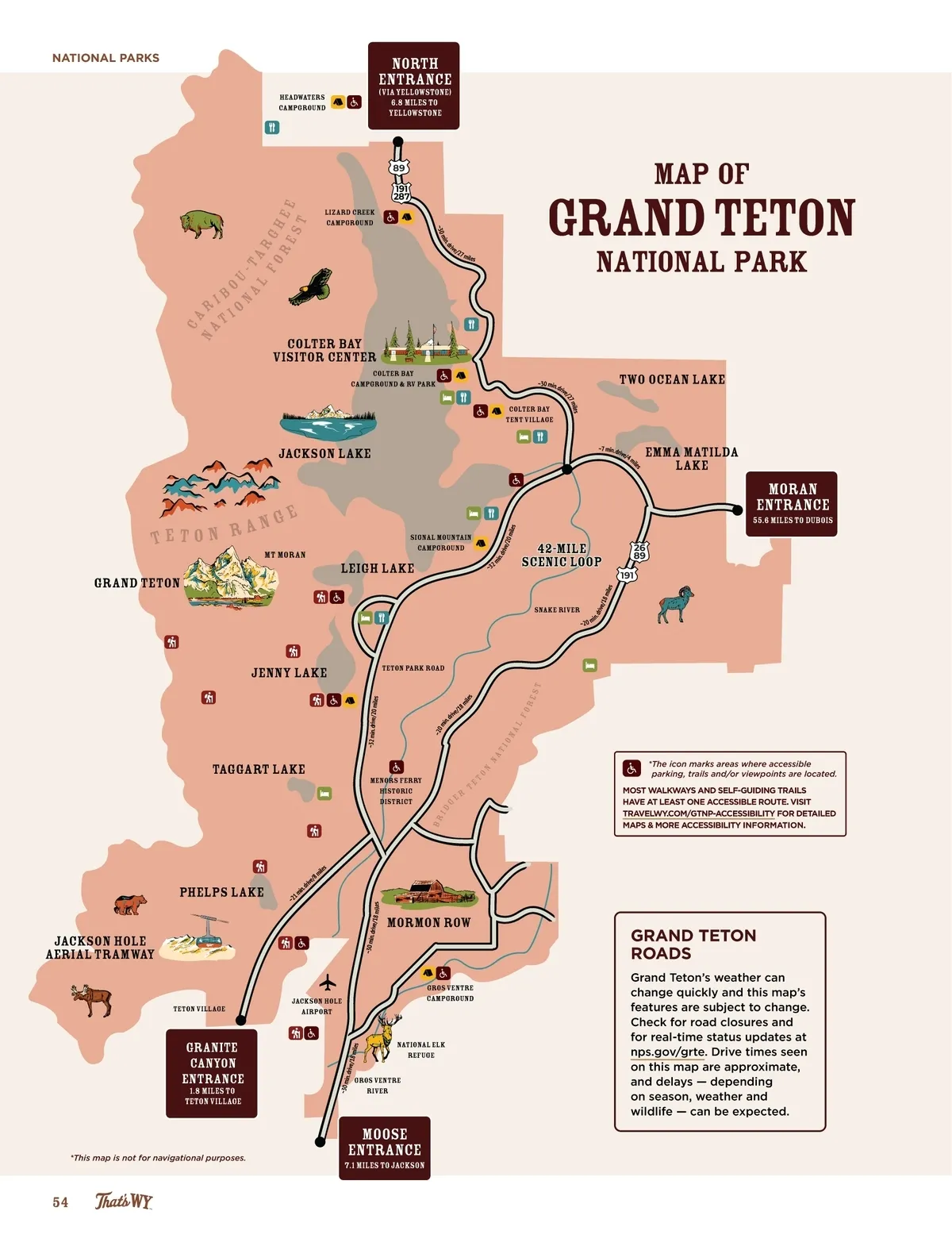
NATIONAL PARKS headwaters campground north ENTRANCE (Via Yellowstone) 6.8 miles to yellowstone 89 191 287 o na u-t l ar fo gh re e e st lizard creek campground ive / 27 Grand Teton miles MAP OF m ~30 dr in. National Park ca na b ri io t COlter Bay visitor center Colter Bay campground & RV park ~30 min. d rive Two ocean Lake miles /27 ~7 min. dr ive/ 4 m il Colter Bay Tent Village Jackson Lake Emma Matilda Lake es mt moran signal mountain Campground mi n. d rive /20 m iles an tet o n r grand teton ge Leigh Lake moran ENTRANCE 55.6 miles to dubois ~3 2 42-mile Scenic loop snake river n. d rive /18 mile s 191 m ~20 i Jenny Lake ~32 min. drive/20 miles Teton Park Road mi les ~20 mi n 8 /1 ive . dr na ti on al fo re st Menors Ferry Historic district ~2 1 phelps Lake Jackson hole aerial tramway 8 e/ riv n. d mi les mi ~30 min . drive/1 8 m iles Mormon Row Br id g er te to Taggart Lake * The icon marks areas where accessible parking, trails and/or viewpoints are located. MOST WALKWAYS AND SELF-GUIDING TRAILS HAVE AT LEAST ONE ACCESSIBLE ROUTE. VISIT TRAVELWY.COM/GTNP-ACCESSIBILITY FOR DETAILED MAPS & MORE ACCESSIBILITY INFORMATION. n GRAND TETON ROADS Grand Teton’s weather can change quickly and this map’s features are subject to change. Check for road closures and for real-time status updates at nps.gov/grte. Drive times seen on this map are approximate, and delays — depending on season, weather and wildlife — can be expected. Teton Village Jackson Hole airport gros ventre campground ~30 m in. granite canyon ENTRANCE 1.8 miles to teton village *This map is not for navigational purposes. 54 drive/ 18 mil es national elk refuge gros ventre river Moose entrance 7.1 miles to jackson
Wyoming Official Travel Guide 2025 Wyoming Official Travel Guide: Page 54