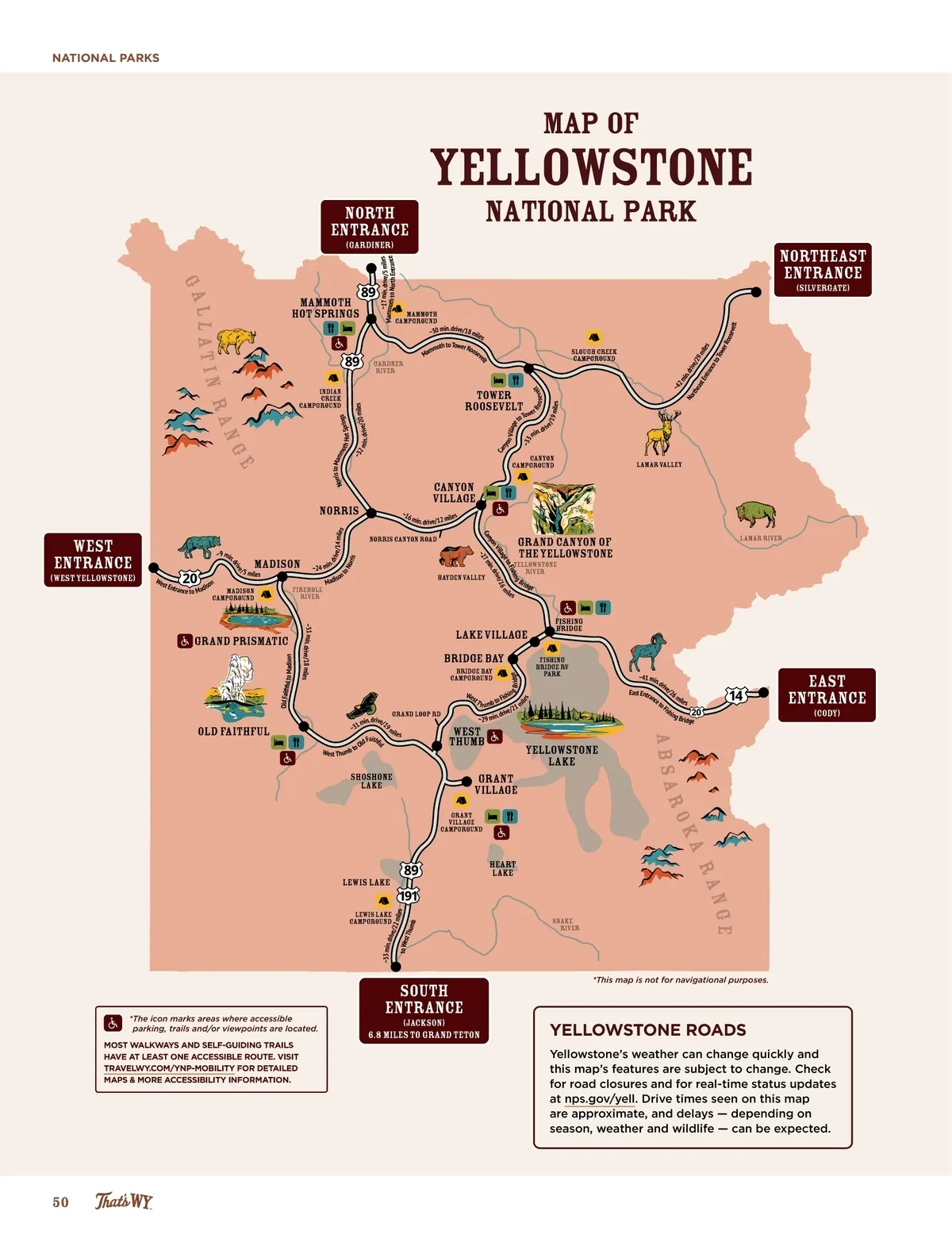
NATIONAL PARKS Yellowstone North ENTRANCE (Gardiner) ~ 1 7 min. drive/5 miles Mammoth to North rance Ent MAP OF National Park Northeast ENTRANCE (Silvergate) in. drive/18 mile ~30 m s to Tower R h t o oos mm ev Ma Roo seve lt Gardner River INDIAN CREEK CAMPGROUND t h H ot Springs SLOUGH CREEK CAMPGROUND 0 miles i n. drive/2 Village is to Mam mo Norr ~32 m Can yo n CANYON CAMPGROUND ~33 . d ri min e/1 r owe to T 9 miles tower roosevelt Ro t o s e v el v LAMAR VALLEY norris ve/14 mil es canyon village ~16 min. d ve/12 miles ri ing Fish e to m lag e/16 Vil driv yon in. Can 7 m ~2 ~4 2 m in. No dri ve/ rth 29 eas mil t En es tra nce to T ow er Ga mammoth hot springs ll at i n Ra MAMMOTH CAMPGROUND elt ng e (WEst YEllowstone) to WEst ENTRANCE Norris canyon road We st En on trance to Madis /5 m iles madison ~24 m i n. N or ris ~9 min. d ri MADISON CAMPGROUND Firehole River n iso Mad HAYDEN VALLEY Yellowstone River Bri dge GRAND CANYON OF the YELLOWSTONE Lamar River grand prismatic Old Faithfu l to Madison g B d ge ri il e s old faithful LEWIS LAKE CAMPGROUND ~33 min. dr ive/ 22 m iles to Wes t Th umb * The icon marks areas where accessible parking, trails and/or viewpoints are located. MOST WALKWAYS AND SELF-GUIDING TRAILS HAVE AT LEAST ONE ACCESSIBLE ROUTE. VISIT TRAVELWY.COM/YNP-MOBILITY FOR DETAILED MAPS & MORE ACCESSIBILITY INFORMATION. ve dri il e s lake village bridge bay BRIDGE BAY CAMPGROUND Wes t T fishing bridge ~31 min. drive/18 miles fishing bridge RV PARK min. drive/1 ~31 mi le s ait ld F hf to O b West Thum Grand Loop Rd shin o Fi h u mb t 1 m e/2 . driv n i m ~ 29 West Thumb grant village GRANT VILLAGE CAMPGROUND ~41 min . dr ive /2 East Entr 6 m anc iles e t o F ish ing Bridge EAST ENTRANCE (Cody) shoshone lake lewis lake (jackson) 6.8 miles to Grand Teton 9 absa yellowstone lake ul ro ka Heart Lake ra nge Snake River SOUTH ENTRANCE *This map is not for navigational purposes. YELLOWSTONE ROADS Yellowstone’s weather can change quickly and this map’s features are subject to change. Check for road closures and for real-time status updates at nps.gov/yell. Drive times seen on this map are approximate, and delays — depending on season, weather and wildlife — can be expected. 50
Wyoming Official Travel Guide 2025 Wyoming Official Travel Guide: Page 50