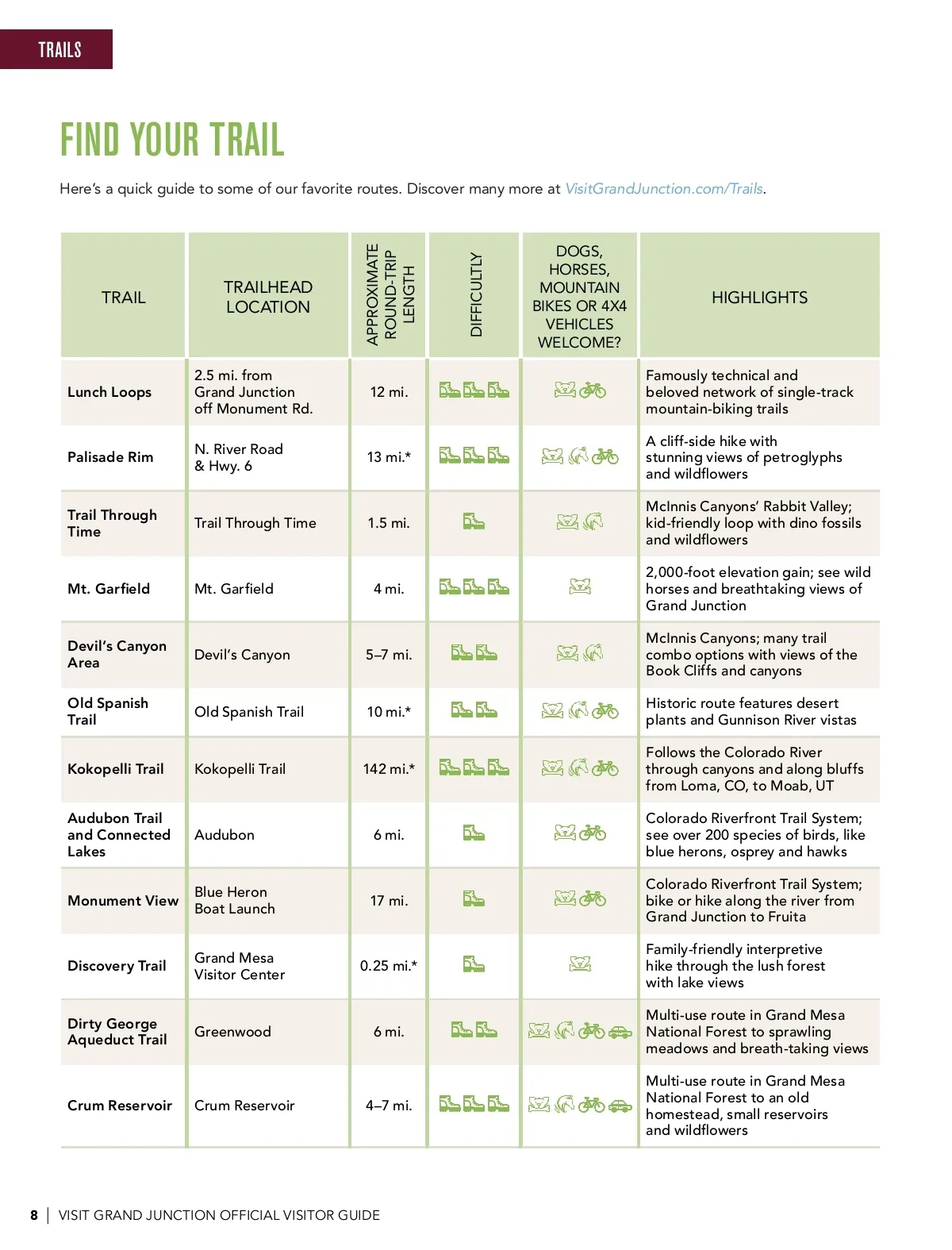
TRAILS FIND YOUR TRAIL TRAIL Here’s a quick guide to some of our favorite routes. Discover many more at VisitGrandJunction.com/Trails. TRAILHEAD LOCATION DOGS, HORSES, MOUNTAIN BIKES OR 4X4 VEHICLES WELCOME? APPROXIMATE ROUND-TRIP LENGTH DIFFICULTLY HIGHLIGHTS Lunch Loops 2.5 mi. from Grand Junction off Monument Rd. N. River Road & Hwy. 6 Trail Through Time 12 mi. Famously technical and beloved network of single-track mountain-biking trails A cliff-side hike with stunning views of petroglyphs and wildflowers McInnis Canyons’ Rabbit Valley; kid-friendly loop with dino fossils and wildflowers 2,000-foot elevation gain; see wild horses and breathtaking views of Grand Junction McInnis Canyons; many trail combo options with views of the Book Cliffs and canyons Historic route features desert plants and Gunnison River vistas Follows the Colorado River through canyons and along bluffs from Loma, CO, to Moab, UT Colorado Riverfront Trail System; see over 200 species of birds, like blue herons, osprey and hawks Colorado Riverfront Trail System; bike or hike along the river from Grand Junction to Fruita Family-friendly interpretive hike through the lush forest with lake views Multi-use route in Grand Mesa National Forest to sprawling meadows and breath-taking views Multi-use route in Grand Mesa National Forest to an old homestead, small reservoirs and wildflowers Palisade Rim 13 mi.* Trail Through Time 1.5 mi. Mt. Garfield Mt. Garfield 4 mi. Devil’s Canyon Area Old Spanish Trail Kokopelli Trail Audubon Trail and Connected Lakes Monument View Devil’s Canyon Old Spanish Trail Kokopelli Trail 5–7 mi. 10 mi.* 142 mi.* Audubon Blue Heron Boat Launch Grand Mesa Visitor Center Greenwood 6 mi. 17 mi. Discovery Trail 0.25 mi.* Dirty George Aqueduct Trail 6 mi. Crum Reservoir Crum Reservoir 4–7 mi. 8 | VISIT GRAND JUNCTION OFFICIAL VISITOR GUIDE
Grand Junction Official Visitor Guide Grand Junction Adventure Guide: Page 8